Day's log for Tuesday, July 24th, 2001 - Georgetown Landing, SC
0955 - added one L of water to the engine cooling system. Need to tighten hoses again.
1000 - raised anchor
1030 - docked and took on 40.7 gallons of diesel
1042 - left dock
1128 - diesel level 5 3/4 inches below top
1130 - passed SM 405
1235 - passed SM 410
At some point in here I got out the GPS and lit it off. It showed that I was making 3 or sometimes as low as 2.5 knots over ground. It was rather frustrating to have to buck the current. I had the current - and the wind against me all day.
1345 - passed SM 415
1441 - passed "Steel Magnolia". Over the VHF I heard this is a custom steel trawler built 10 years ago in Houston and the guy driving it was the delivery captain. It looked like a really nice boat.
1542 - passed SM 425
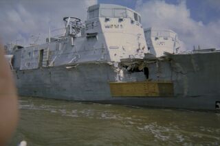
These were two small navy boats that were lashed together and being pushed to a repair facility or a salvage yard. Maybe I can take better care of my boat.
1634 - passed SM 430
About this time I heard over the VHF a funny thing. As is often the case I heard only one side of the conversation but it is pretty easy to figure out the rest. This vessel (unnamed) was talking to a bridge tender who explained that he could not open the bridge until 1830 because of ongoing repairs. The (unnamed) then called the Coast Guard to complain. They carefully explained that this was an SCDOT issue and they couldn't help. A few minutes later I heard a more emphatic reply from the Coast Guard to the same (unnamed) vessel stating why the bridge was closed. Folks, the world works a certain way - figure it out and stop complaining.
1728 - passed SM 435
1825 - passed SM 440
At this point I started looking for a marina or a safe spot to drop the hook. I was seeing absolutely nothing of the sort on the waterway or the chart.
1924 - passed SM 445
1940 - saw dolphins. It passed through my mind that seeing dolphins has turned out to be a prelude to difficulties on this trip.
2015 - sunset
2045 - anchored near day marker number 90. The anchor dragged and it wasn't a real good spot anyway since it was really close to land on two quadrants. If I stayed here I would have to stay up all night watching things.
Got the searchlight out to use to see the banks. I plugged it in and turned the search light switch on. Take a wild guess what happened next! The search light came on then went out. I could not get it to switch back on. The mini-mag does not effectively illuminate the banks. I cursed the search light and what I had to face doing - going down the ICW at night. It gets dark quick in these southern lattitudes.
2055 - raised anchor and continued. I continued motoring toward the blinking lights. Those on the ICW blink 4 seconds for the red and 2.5 seconds for the green at turning points. By now it was completely dark. I approached number 94 which was unlit and had to use my mini-mag to see it. It has reflective tape for better visibility. I passed it safely. This is getting a bit hairy. I did not relish the prospect of continuing like this for ten miles to Isle of Palms where there might be a marina. I continued carefully steering to number 96 only I could not see the number - I just kept track of where I was and knew by that. At 2100 I also saw on the chart another creek - Whiteside Creek. It had 23 feet of water and was off the channel - good enough! I pulled in and saw two sailboats well apart at anchor. I dropped the hook in the middle and let out plenty of scope as there was a good tidal current and winds out of the south.
2115 - anchored - and breathing a sigh of relief!
Prev Home Next